

A PIONEERING new project aims to reveal archaeological treasures hidden in the Wyre Forest area by using laser beams shone from the sky to "see through" the trees.
The new laser technology will help uncover everything from ancient settlements and fortifications to farms and any other signs of human activity which, especially in woodland, are often difficult to detect from the ground or the air with the naked eye.
Scientists from the Forestry Commission's forest research agency have teamed up with the Worcestershire historic environment and archaeology service to use innovative aerial survey techniques, known as LiDAR - Light, Detection & Ranging.
It uses pulses of harmless laser energy beamed down from aircraft flying about 3,300 ft up.
The team's initial work and future plans for the project will be unveiled at a public seminar, titled Wyre Forest Landscape - Unravelling the Past, which is being held at Worcester University from 7pm on Tuesday.
The project is part of the Grow With Wyre landscape partnerships scheme, which aims to restore the landscape to its former glory.
Project manager, Gail Atkinson, said: "Local history enthusiasts and lovers of the outdoors alike will get the first chance to learn more about this exciting new project at the event.
"Our team of experts will discuss the breakthrough aerial survey techniques being used to unravel the complex landscape history and features that have already started to emerge in the Wyre Forest landscape."
The Wyre Forest LiDAR project has been made possible thanks to funding and support from the Heritage Lottery Fund and SITA Trust and GrantScape.
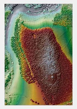
LiDAR works by "bouncing" laser energy off the land in much the same way as radar bounces radio waves off solid objects and measures the time it takes for the pulses to be reflected back to recording instruments in the aircraft.
That produces data in the form of millions of three-dimensional co-ordinates, which are processed by computers and turned into images of the ground that look as if the trees had been stripped away.
Any ground features that look as if they might have been made by humans rather than nature can easily be spotted and investigated to see whether they indicate the presence, or former presence, of buildings, trenches, mining sites or other features.
Adam Mindykowski, historic environment countryside adviser for the Worcestershire historic environment and archaeology service, said: "The Forestry Commission LiDAR survey provides an unprecedented insight into the historic landscape of Wyre Forest and its hinterland."
Anyone interested in attending the seminar in Worcester should e-mail Alison Coggon at Alison.coggon@forestry.gsi.gov.uk or call her on 01584 813828. Spaces at the seminar are limited and will be allocated on a first come, first served basis.


Comments: Our rules
We want our comments to be a lively and valuable part of our community - a place where readers can debate and engage with the most important local issues. The ability to comment on our stories is a privilege, not a right, however, and that privilege may be withdrawn if it is abused or misused.
Please report any comments that break our rules.
Read the rules hereComments are closed on this article